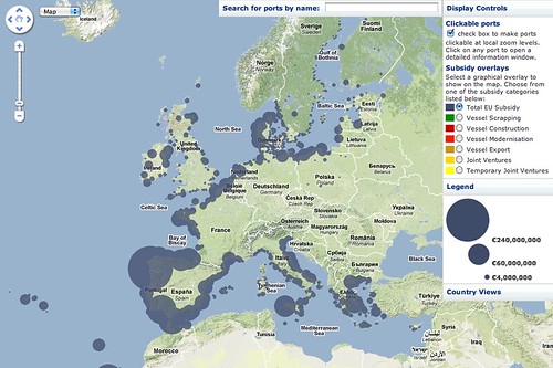
The folks over at Fish Subsidy (who are also behind the amazing Farm Subsidy project) have just released a new mapping tool to help people find out how €3.4 billion of European fisheries subsidies is spent:
- This is a great example of reusing European public data to make it easier to understand for citizens, journalists and others. The project highlights how important it is for public bodies to make data legally and technically reusable, not just available online via an official ‘shiny front end’, so that others can do interesting things with it.
The project also releases all of their cleaned up data under a fully open license, which means that others can continue to do interesting things with it (like connect it with other data sources, produce new visualisations, and so on):

From the press release:
LONDON, Monday, 8 November 2010—fishsubsidy.org today launched an interactive map that allows European citizens to track €3.4 billion in EU fisheries subsidies. The map shows 39,174 payments to vessels from 1994 to 2006 under the Financial Instrument for Fisheries Guidance (FIFG).
Users can select categories of payment (vessel construction, modernisation, scrapping, etc.) and see clearly the geographical distribution of funds, both across the continent and in member states, including the outermost regions. The map also provides summaries of all payments to individual ports with links to the vessel pages at fishsubsidy.org.
“This new resource reveals where the money went, identifying which regions and ports benefited most from fisheries subsidies. The largest subsidy recipients were in Spain, where public money has fuelled greater and greater fishing capacity, exerting ever more pressure on already depleted fish stocks,” said Markus Knigge of the Pew Environment Group. “Rather than propping up a subsidies-addicted industry, the EU should invest in conserving valuable fish stocks and securing the future viability of vulnerable fisheries-dependent communities.”
The maps cover payments only up to 2006. “Unfortunately, the new system of transparency that applies to the European Fisheries Fund (EFF) is deficient in a number of respects, the most important of which being that data disclosed no longer identifies the vessels for which subsidies were paid,” said Jack Thurston of EU Transparency.
If you’re interested in talking to the project about the release, you can call or email Jack!
Dr. Jonathan Gray is Lecturer in Critical Infrastructure Studies at the Department of Digital Humanities, King’s College London, where he is currently writing a book on data worlds. He is also Cofounder of the Public Data Lab; and Research Associate at the Digital Methods Initiative (University of Amsterdam) and the médialab (Sciences Po, Paris). More about his work can be found at jonathangray.org and he tweets at @jwyg.


1 thought on “New mapping tool from European Fish Subsidy project”
Comments are closed.