The following guest post is by Josh Powell from Development Gateway, who works on their AidData programme.
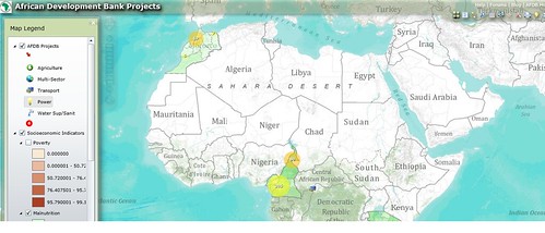
Last week, the geocoded locations of all African Development Bank (AfDB)
projects continent-wide approved from 2009-2010 were made available at open.aiddata.org. The data include more than
$10 billion in AfDB Group funding to 43 African countries, and were geocoded through
a partnership between the
AfDB and AidData. You can also explore the data for three of these countries—
Cameroon, Morocco, and Tanzania—through an interactive map called Development Loop. Meanwhile, last autumn, the World Bank unveiled its maps.worldbank.org website, which shows project locations around the world. Using these data sets, stakeholders can,
for the first time, view the precise locations of schools, hospitals, roads, bridges, and other activities
financed by these donors.
The underlying motivation behind these two data releases is the increasing citizen demand for donor
transparency and open data. As IATI signatories, both the AfDB and
World Bank (through its Open Data Initiative and Mapping for Results program) are finding new and innovative ways to inform the public about their
activities. If other donors followed suit, the potential is huge — comprehensive, readily available geo-
data for all donors could not only improve service delivery and decrease corruption (as researchers
found when local public funds were announced in Uganda), but could improve donor division of labor and aid targeting to the
neediest areas within a country.
An ongoing project, led by the Malawi Ministry of Finance (MoF), is attempting to demonstrate both
the possibility and benefits of an open geo-data set for all of the 29 aid donors in its Aid Management
Platform. In partnership with AidData and University of Texas
researchers (from UT’s Climate Change and African Political Stability program), the Malawi MoF has
been collecting data from its donors for geocoding. Coding activities are still ongoing, but the data
set, which will include nearly 800 aid-funded projects worth nearly US$7 billion, will be made publicly
available in advance of the High Level Forum in Busan, South Korea.
By providing open access to this type of comprehensive, granular data set, the Malawi MoF and its
donor partners are providing researchers, beneficiaries, and civil society with the ability to examine
donor activities and coordination, verify that promised aid is being delivered, and improve the impact of
aid through increased efficiency. Moreover, by demonstrating the feasibility of multi-donor geocoding
using a harmonized methodology, the Malawi
project can increase the demand for open geo-data for all donors and governments committed to
transparency and accountability.
Theodora is press officer at the Open Knowledge Foundation, based in London. Get in touch via press@okfn.org